REFERENCE FRAMEWORK
The environmental planning, since some years, has a main goal that is the mitigation of
fragmentation impacts by means the integrate researches between territorial and
environmental sciences and an action on control instruments of territorial
transformations (Romano 2000).
To obtain these results it’s necessary to implement methods and criteria for identifying
the relation among the parameters which describe status and evolutions conditions of
the biological components and the settlement transformation phenomena.
The clear goal of these researches, now in progress, is that to establish the links between
the rules of urban planning - relative to the civic quality of the cities and territories -
and the effects on the ecosystem structure due to urban evolution. Is particularly
important to know and draw the environmental condition before and after the anthropic
transformations.
Since some years is in progress the proofs to realize a conceptual and experimental
union between two thematic sets of indices (Battisti 2003, Biondi et alii 2003), but we
cannot say now to have reach the efficient results, because we have again
methodological and instrumental difficulties.
The present paper to show the characteristic data and indices on urban spaces structure
and configuration. These indices has been implemented on the bases of the Landscape
Units for linking it with biodiversity analytical data to highlight causa-effect relation.
These territorial units are obtained from overlay processes on climatic, morphological
and geo-litological layers and have an important influence on vegetation landscape and,
consequently, on total biodiversity. But these units are determinant for the urban
landscape also and so can assume a significance role of analysis and interpretation units
of urban settlement phenomenon.
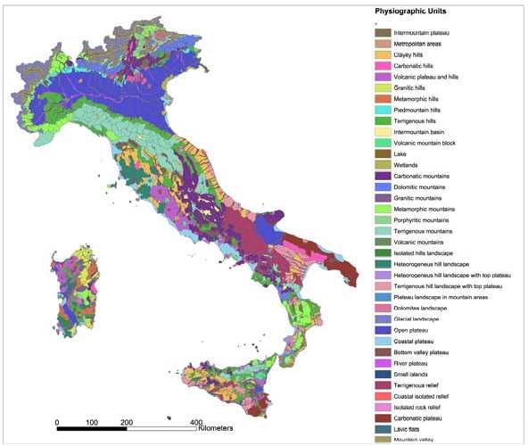
Different italian regions have today the maps of Landscape Units, but it is today
available just one national layer: Physiographic Units implemented by Environmental
National Agency (APAT) as reference base for implementing the National Natural Map
(APAT 2004).

Figure 1 - Physiografphic units in Italy implemented from Environmental National Agency (APAT)
More intriguing information
1. The name is absent2. Evaluating the Impact of Health Programmes
3. Surveying the welfare state: challenges, policy development and causes of resilience
4. Categorial Grammar and Discourse
5. Unilateral Actions the Case of International Environmental Problems
6. The name is absent
7. The Impact of Minimum Wages on Wage Inequality and Employment in the Formal and Informal Sector in Costa Rica
8. Artificial neural networks as models of stimulus control*
9. Towards a framework for critical citizenship education
10. Licensing Schemes in Endogenous Entry