Figure 3 - Percentage of urban areas for each different kind of national landscape units
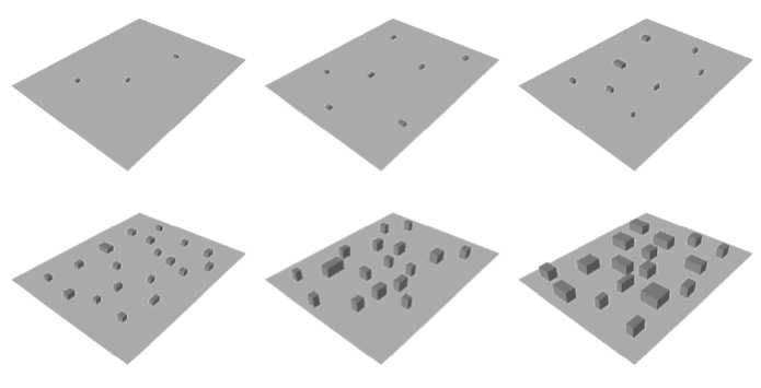
Figure 4 - Tri-dimensional models of increasing territorial urban density from
UD=15 mq/ha (high to left) to UD=1000 mq/ha (down to right).
Urban dispersion (URD)
this parameter regards the distribution of urban nucleus (obtained as centroids of the
different urban areas polygons) within the considered spatial units. It is possible to have
the simple formulation of URD (e.g number of nucleus/units area), or other formulation
that could consider the distances among the nucleus. The URD data have to be
interpreted together the UD because to give the settlement structural characteristics and
could be linked directly to the disturbance typologies on the natural matrix.
More intriguing information
1. New Evidence on the Puzzles. Results from Agnostic Identification on Monetary Policy and Exchange Rates.2. The name is absent
3. The name is absent
4. On s-additive robust representation of convex risk measures for unbounded financial positions in the presence of uncertainty about the market model
5. Return Predictability and Stock Market Crashes in a Simple Rational Expectations Model
6. The Macroeconomic Determinants of Volatility in Precious Metals Markets
7. Short- and long-term experience in pulmonary vein segmental ostial ablation for paroxysmal atrial fibrillation*
8. EDUCATIONAL ACTIVITIES IN TENNESSEE ON WATER USE AND CONTROL - AGRICULTURAL PHASES
9. FDI Implications of Recent European Court of Justice Decision on Corporation Tax Matters
10. Social Irresponsibility in Management