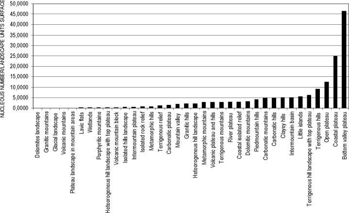
Figure 5 - Urban Dispersion histogram relative to Italian landscape kinds, obtained as ratio between
urban nucleus number (font: Corine Land Cover Level 3) and the surface in hectares of the
Physiographic Unites designed by APAT on 2004.
Infrastructural Fragmentation Index
The fragmentation caused by road infrastructure may be assessed by means of separate
indices according to the type of infrastructure (motorways, railways, main roadways,
local roadways, and overall standardised index) depending on the different features of
environmental obstruction that each category entails for wildlife (Romano 2002).
Infrastructural fragmentation may be measured using the Infrastructural Fragmentation
Index (IFI):
IFI = ∑ (Li*oi) * li/Au
(1)
where:
Li = Length of the infrastructure (excluding tunnels and viaducts);
oi = Obstruction coefficient of the infrastructure, depending on the type of infrastructure
and traffic flow;
li = Road width ;
Au = Area of the reference territorial unit;
In relation to obstruction coefficient, oi=1 in the case of motorways and railways (total
obstruction due to side fencing), while, in the case of roads with a high volume of traffic
(with significant obstruction due to noise and permanent movement), the obstruction
coefficient oi is expressed as a function of the traffic flow on the section of the road
considered.
In a given road section, with a traffic flow equal to n vehicles per hour, the time during
which the same section is free from transit is equal to:
More intriguing information
1. Anti Microbial Resistance Profile of E. coli isolates From Tropical Free Range Chickens2. Shifting Identities and Blurring Boundaries: The Emergence of Third Space Professionals in UK Higher Education
3. Delivering job search services in rural labour markets: the role of ICT
4. Lumpy Investment, Sectoral Propagation, and Business Cycles
5. Gender stereotyping and wage discrimination among Italian graduates
6. The use of formal education in Denmark 1980-1992
7. A Principal Components Approach to Cross-Section Dependence in Panels
8. A Consistent Nonparametric Test for Causality in Quantile
9. The name is absent
10. The name is absent