oi = Coefficient expressing the level of obstruction that is characteristic of the various
types of urbanised areas for the species considered. By using a simplified rationale, to
obtain an indication at territorial level, the following values may be viewed as
significant:
a) Industrial areas and the like: oi =100%
Presence of concentrated pollution, heavy traffic, noise, lights and disturbance even at
night, presence of large paved areas, general lack of green areas.
b) Business districts and the like: oi =80%
Presence of large paved areas, night lighting, significant daytime traffic flows, greater
general presence of green areas and vegetation compared to case a).
c) Intensive residential areas : oi =60%
Presence of concentrated pollution, noise, daytime disturbance, general presence of
green areas and vegetation that is more distributed and widespread than in case b).
d) Extensive residential areas: oi =40%
Scattered housing, greater spreading of disturbance, presence of vegetation and green
areas, both within private plots and in public areas, generally greater compared to case
c).
Sensitiveness towards the use of land for widespread urbanisation can provide a
significant indication for the development of environment-friendly planning tools. This
involves understanding how an area will respond to the use of land due to the gradual
expansion of urbanised areas, following the creation of some favourable conditions
related to the geographical and social structure, as well as local and external economic
factors.

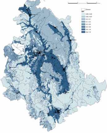
Figure 10 - UFI index implemented on landscape units of Umbria region
More intriguing information
1. ENVIRONMENTAL POLICY: THE LEGISLATIVE AND REGULATORY AGENDA2. The Economics of Uncovered Interest Parity Condition for Emerging Markets: A Survey
3. Investment and Interest Rate Policy in the Open Economy
4. KNOWLEDGE EVOLUTION
5. The name is absent
6. Developmental changes in the theta response system: a single sweep analysis
7. Infrastructure Investment in Network Industries: The Role of Incentive Regulation and Regulatory Independence
8. Towards a framework for critical citizenship education
9. The name is absent
10. The Folklore of Sorting Algorithms