The first objective of this strategic document can be pointed as follows: study the available
information and collect other required information on the mobility and transportation issues of
municipality and its surroundings in order to elaborate a diagnosis of the present situation.
After the diagnosis, it is possible to identify potential interventions, by order of importance, and
more important, it will be possible to analyse the cross-impact of the interventions proposed, not
only between themselves, but also regarding other sectors of the municipality.
Due to the specific attributes of the municipality the analysis had to be made both at the
municipality scale but also at the scale of the city of Alcobaça, the main town of the municipality.
There where three main objectives to which the proposals of potential interventions had to be
linked with (for the purpose of this paper, only the municipal scale will be detailed):
o The Intra Municipality relation
o Urban Parking in Alcobaça
o The territory competitiveness at a regional scale (West Region)
3.2 Summary characterization of the Municipality of Alcobaça:
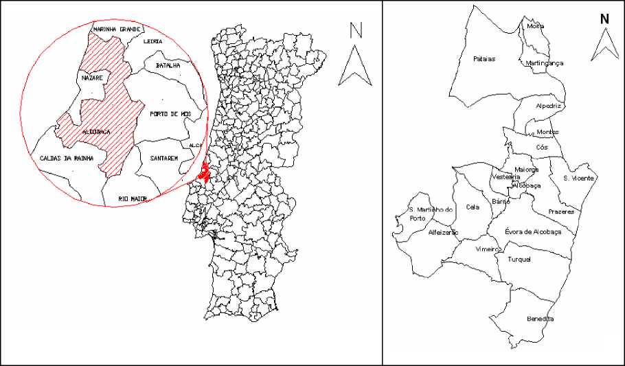
Located at 100 km from Lisbon and 30 km of Leiria, it is connect to the municipalities of Caldas
da Rainha, Leiria, Nazaré (main regional poles of growth). The municipality of Alcobaça is divided
in 18 freguesias (the smalles administrative limit of Portugal, the English translation would be
parish), it houses 53 000 inhabitants in its area of 409 Km. The four most important parishes are
Alcobaça, Benedita, Pataias, and Sao Martinho do Porto (Figure 2).

Figure 2 - Location map of the Municipality of Alcobaça
8/17
More intriguing information
1. Impact of Ethanol Production on U.S. and Regional Gasoline Prices and On the Profitability of U.S. Oil Refinery Industry2. The name is absent
3. The Integration Order of Vector Autoregressive Processes
4. Weak and strong sustainability indicators, and regional environmental resources
5. A Critical Examination of the Beliefs about Learning a Foreign Language at Primary School
6. Sustainability of economic development and governance patterns in water management - an overview on the reorganisation of public utilities in Campania, Italy, under EU Framework Directive in the field of water policy (2000/60/CE)
7. The name is absent
8. The name is absent
9. Word Sense Disambiguation by Web Mining for Word Co-occurrence Probabilities
10. The effect of classroom diversity on tolerance and participation in England, Sweden and Germany