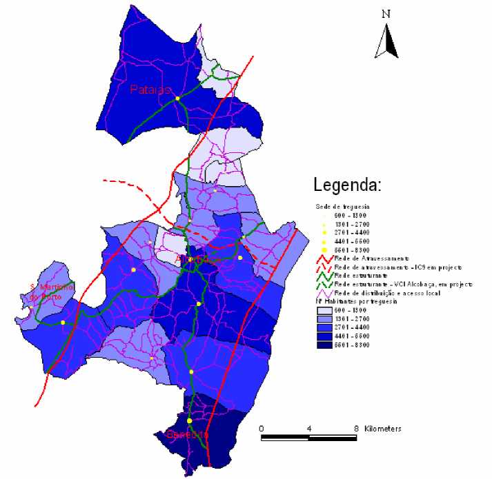
GIS was used in order to perform some of the road network analysis (field trips, survey data and
other cartographic information were at the basis of these analysis). The first results suggested a
hierarchical organization of the network that was revelling of two major alignments (A8 and N1)
mainly focused on regional circulation. At finer grain, a star shaped structure of National Roads,
centralized in Alcobaça, was clearly playing a structural role road to the main city and to the
municipality, connecting almost all parishes via Alcobaça.
Road Network Hierarchy

Figure 4 -The Road Network Hierarchy
The A8 freeway is one of the most important structures of the region. Before its opening a few
years ago, the accessibility of this region and the municipality was poor, in part because of the
mountain terrain, in other part because of the age of the network. With this freeway, the parishes
of Sao Martinho do Porto, Alcobaça and Pataias, get much more closer of Lisbon (not much more
than an hour) and closer to the nearby municipality of Leiria (just a few minutes distance).
Another relevant point to be made is the centralization of the network in Alcobaça. That is positive
from the point of view of the accessibility of/to the city, however, it brings difficulties to other
connections and problems to the city itself, since like many others urban areas in Portugal and in
the municipality the main roads crisscross the main urban/dense nucleus of the city causing
unnecessary congestion problems.
11/17
More intriguing information
1. The name is absent2. The name is absent
3. Education Responses to Climate Change and Quality: Two Parts of the Same Agenda?
4. AN EXPLORATION OF THE NEED FOR AND COST OF SELECTED TRADE FACILITATION MEASURES IN ASIA AND THE PACIFIC IN THE CONTEXT OF THE WTO NEGOTIATIONS
5. FUTURE TRADE RESEARCH AREAS THAT MATTER TO DEVELOPING COUNTRY POLICYMAKERS
6. Giant intra-abdominal hydatid cysts with multivisceral locations
7. The name is absent
8. Mortality study of 18 000 patients treated with omeprazole
9. The Value of Cultural Heritage Sites in Armenia: Evidence From a Travel Cost Method Study
10. Locke's theory of perception